

This partially ruined wall marked the edge of the Roman empire in 122AD when Emporer Hadrian, struggling to invade Scotland while dealing with his rebellious British subjects at the same time, withdrew troops from the more Northerly Antonine Wall (earth ramparts) to consolidate their position. At 6m high this engineering feat took three Legions (15,000 men) only 6 years to build and is a symbol of both the power of Rome and it's limitations. It stretches from Newcastle-upon-Tyne in the North East of England in an almost straight line clear across the country to Carlisle, and then on to Bowness-on-Solway where the river becomes unfordable and attacks from people wading across would no longer have been possible.

This idea of what it means to be invader and invaded has been with me for a long time, and the Wall symbolises a lot of that for me. My dad and uncle walked it together a few years ago while I was in university, and I'd been hoping to do the same (although unlike them, we won't have to walk from the Wall to our lodgings each night, as Nathan and Dad will be having a parallel holiday and have kindly agreed to pick us up and drop us off each day!) This year I mentioned it to my Mum and we decided to do the trip together. We would start at Heddon-on-the-Wall, the first place the Wall itself becomes visible, and finish in Carlisle. It's a 55 mile trip, it was to take us almost five whole days of walking, and as usual I kept a diary...
Day 0 - Arrival
Took the train to Doncaster to converge with the family car, then on to Carrow. I'm sitting out in the garden of our 4* B&B (bless you, Mum and Dad!) on the tail end of a gloriously hot summers day, breeze blowing, nary a car to be heard, and the South stretched out in front of me. It's a great vantage point - I can see why you'd build a military wall here. We'll actually be passing this exact spot on Day 2 of our walk.
- It's Hadrian's Wall. THE Hadrian's Wall! I'm somewhat fascinated by that time period and what it meant to be a country invaded and occupied by another - and then to be abandoned by them. The Wall to me is a big symbol of that.
- That fact that it's almost 2000 years old. The events it's withstood. I want to root myself deeply in the oldest history of my own country.
- Not denying a fan's love of 'The Eagle of the Ninth' by Rosemary Sutcliffe, particularly the characters of Marcus and especially Esca. The Roman and the British. What it meant to be invaded and invader, to see your home and culture eroded and to go native, to bridge the gap between individuals where empires stood apart. See my first point but it's about what the Wall represents rather than the physicality of it. A border, a protective barrier, an obstacle to freedom or trading, an opportunity, a workplace, a frontier. A sign of pride or disgrace. It cuts right through the Brigantes land that we now call the Borders. What must that have been like?
- A distance walk. The Wall itself is just a marker. I aim to walk the breadth of my own country (bar Newcastle, which I'm not sorry to be skipping!). I've never done a continuous walk like this, and never one of this length. It's the shorter of Britain's many long walks, but a decent enough challenge for a first try.
I did not think ahead about lunches. I'll need to find something in Heddon or Chollerford - some bread, peanut butter, and jam to make sandwiches perhaps.
We start tomorrow.
Day 1 - Heddon-on-Wall to Chollerford - 14 miles
Last night at dusk the mist rolled in from the Tyne. It seeped into the lower valleys and pooled there, and then advanced up the hill in a great white wall. By 10pm the bottom of our hill was invisible. I woke up randomly sometime after 5pm to see it was daylight and three rooks sat on the garden wall in front of the mist. It was very Edgar Allen Poe.

We were dropped off at Heddon-on-the-Wall, the first place since Wallsend you can see exposed Wall, although for some reason Mum marched off without doing so! It was soon clear that the day would be a scorcher and the zip-off trouser-shorts soon proved their worth. There isn't a lot of Wall to be seen on this first stretch. Mostly the path tracks alongside Military Road, which was unknowingly built on top of the Wall. There are a few farms to skirt around, but for the most part it's a steady march through the ditches and fields that run alongside the road. There are meadows and fells to either side and the views really are spectacular. We set off about 9.30am and by 12.30pm had reached the Vallum Tearooms, rightly recommended to us for it's ice cream. Making good time, we carried on to the Errington Arms, and then forged on up a slope towards Harlow-on-Hill. Realising we were trudging a lot, and discussing Mum's current school topic on the Romans we tried out some marching tunes as we went along. Seeing the point of them now - the pace quicken and evens, the stride lengthens, and it's good for getting a bit more energy out of the harder uphill slogs.
And it was very hot. Death by melting seemed likely at several points. Because the idea of the Wall is to see all round it's built along the top of the hill line most of the time, and so is very exposed. There was a breeze later in the afternoon which was very welcome. We did see a lot of the Vallum, the wide ditch that runs (bizarrely) to the South of the Wall. Normally a defensive ditch is on the same side of your wall as any potential invaders, making it a harder climb for them. There was a military/drainage ditch to the North too, so no one really knows what the Southerly Vallum is actually for! There are also a few marked earthworks showing where the remains of Rudchester fort's foundations are buried, and another at Halton. By roughly 4pm we'd reached the tearoom at St Oswalds, where we met Nathan and Dad. Being stubborn Barnett women we elected to tackle one more hour's walk to Chollerford. Famous last words.

We did, however, get to see our first stretch of extant (visible) Wall - the point at which the Broad Wall, at 3m wide, becomes the Narrow Wall at 2m wide. Wonderful to finally see and touch what had been buried under the road this whole time. Also detoured a little to see Brunton Turret. It extends a good 2m above the ground and gives you a good idea of the size of the thing. There were 2 turrets between each milecastle (gateway). That last hour felt like the longest hour of our lives. I was getting footsore, though not too weary, but Mum was pretty tired. We'd stayed hydrated but the intense heat can't have helped. Finally we stumbled into Chollerford for our lift back to the B&B. My feet, ankles and calves feel a little hard done by, but Mum was worse off.
Although today's 14 mile hike will be one of our longest, her bag had been rubbing on her lower back without her noticing (I know she didn't do the waist-strap up much - don't know if that altered anything) and her lumber bore a nasty heat blister. It was raised and red and obviously swollen or fluidy, and the skin was even broken in one place. It should shrink down as it cools but I reckon it'll take at least two days to be proddable. In the meantime she's travelling light with just a bumbag and rockets full of apples. I'll be shouldering the extra water, and anything else we bring. Neither of us have any other foot blisters, and although I got nettled quite badly I found some dock leaves so we're doing well so far. Dinner at .... , a quick stop in the village of Wall (Stardust reference, anyone?) and watched The Eagle with Nathan. 'Cause you can't walk the Wall and not see/read The Eagle! Hazy, but no mist tonight. Possibly got a cold coming on. Warn weather should help keep it at bay. Fingers crossed. Sleeping without pyjamas again tonight. Too hot for otherwise.
Day 2 - Chollerford to Housesteads - 8 miles
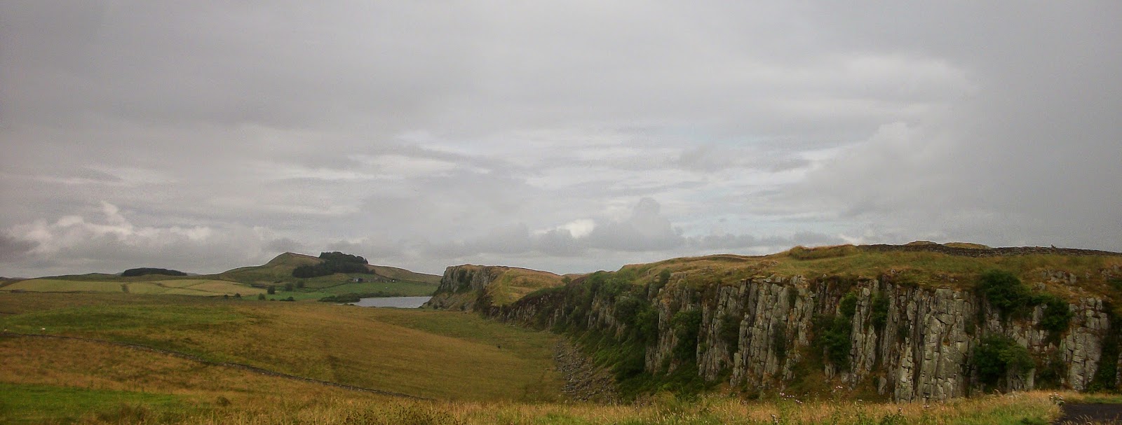
Started the day with a hill - the B6318 Military Road trundles on, into some fields and then over a small escarpment. Then it's a straight shot over open ground. Mercifully it's a little cloudier then it was yesterday and walking on the heights means there's a breeze, which I need. After the village of Walwick you walk straight through to Sewing Shields farm, where you start going uphill again to the impressive Sewingshields Crags. I don't need to tell you how amazing the views are. With a few scattered farms, vast tracts of land either side of the Wall look more or less as they would have 2000 years ago.

Other neat things we passed were Limestone corner - the Northernmost point of the Roman Empire before the Wall bows South towards the line of the hills that begin at Sewingshields. Also a surprisingly intact Mithraic Temple at the buried fort of Brocolitia. Being a mystery religion it's hard to find out a lot about it so it was great to see something so complete.
 |
| Mum and me at Limestone corner! |
 |
| Mithraic Temple - You can see the remnants of the ceiling pillars, and and the altars at the far end. |
At some point before Sewingshields I had a slump where I was tired and quiet and thinking "this isn't fun anymore." My ankles were aching too, although I'd avoided Mum's heat blister by taping my back where I saw it start to appear. After some biscuits I felt better.
We haven't really been having lunches, not wanting to be walking on a full stomach. We have a hearty breakfast, an equally hearty dinner, and not much in between save for the odd banana or snack, and several bottles of water each day. It seems to be working, and a mid-afternoon sugar rush is always welcome.
At Sewingshields you go up onto some amazing crags that begin the long spine of hills that characterise this phase of the walk. The hills slope up from the South and drop off sharply on the North, with a few gaps between the hills that made gates for locals and traders to pass through. They are amazing but abrupt and quite steep. Following them, you end up at Housesteads Fort. This is a great example of an excavated fort. You can see in great detail the barracks, latrines, and the layout of the hospitak, commander's quarters and so on. Two actors gave us views of the Wall from the British and Roman points of view. I was tired and hot, sweat standing clear on my forehead, but after a sit down, followed by a lie down, and removing my shoes, I felt a lot more human.
 |
| Heading up to Housesteads |
 |
| The hypocaust under the floor of the granary at Housesteads, still perfectly intact. This kept the food stores aerated and prevented dampness and mould. |
Our B&B lodgings are now at the self-catered Lanercost, a pretty impressive looking set of buildings built around an old priory that is built from parts of the Wall! Very exhausted and looking forward to a quiet evening in, dinner cooked by brother, and a lazy start tomorrow.
Day 3 - Housesteads to Steel Riggs - 4 miles
Last night the weather finally broke. From about 9.30pm through to midnight we had a very welcome downpour that will at least take all the still heat out of the air. How lovely it is to admire bad weather from somewhere warm and dry!

We had a slow start in our new habitation at Lanercost, heading out at 11pm, not for the Wall but for the nearby fort of Vindolanda. Since the 1970s it's been steadily excavated and the unique conditions there mean that vast amounts of artefacts have survived. You can see clearly the layout of the fort and barracks, the different rooms, and how the vicus huddled alongside it, living off it and supplying it. Although not part of Hadrian's Wall such monumental discoveries have been made here that it's worth taking half a day out to see it properly and do it justice. There is a collection of assorted shoes - no two alike. They were thrown into the military ditch when they were beyond repair, and preserved there in the clay. Each show represents a person - a life - lived two thousand years before mine. They also have, among the spear- and arrow-heads, brooches, skeletons and stonework, examples of some of the earliest Roman handwriting on thin wooden pages, including one of the first of a woman's handwriting. Normally a scribe would be used but in this one instance the commander's wife has added a fond greeting in her own hand!

 |
| Keys to the chests and doors of the fort |
 |
| Hair pins, probably belonging to the richer women in the fort and vicus |

 |
| It's a whole wall of Samian pottery. A WHOLE WALL!!! |
 |
| Blue Roman glass. When they talk about the blue paint of the native Britons, this is the colour they compare it to. |
The weather today had turned and was authentic Northern fare at last. Clear in the morning, the day clouded over by lunchtime and we had one heavy shower to start, and then the intermittent rain and wind through the afternoon. Honestly though, I enjoyed it more than the sun. It was finally cooler, the wind and rain were refreshing as we warmed up, and patchy rather than torrential. I'd rather be cool than baking as I walk because (like my Dad) I'm more given to sweating than Mum and I hate feeling hot. We trekked up and down, up and down, maybe half a dozen times in the few hourse. Met more people on this popular stretch on the walk, and also passed the famous Sycamore Gap. ("I'm five miles from home!" Really, Loxley? Really? Where on earth have you taken that poor man?) The brother and Dad were done with sightseeing after a few hours, so we met them at Steel Riggs after 2hrs walking. But worth it for Vindalanda and a relaxed half day. Feeling rested and ready for another full day tomorrow.
 |
| The crags from Steel Riggs |
 |
| Oh, that Sycamore Gap. Got very fangirly over it :) |
 |
| Like a very veeery slow rollercoaster |
Day 4 - Steel Riggs to Lanercost - 12.5 miles
Started at Steel Riggs, and soon clear it was going to be another hot walk. Very uncharacteristically glorious summer day. Our morning was spent traversing more crags, including the highest point of the walk and the crossing into Cumbria. We met a volunteer ranger who does the whole walk once each month, and clued us in on some of the Wall's features. He clearly loves it, and often walks extra parts just for fun! More stunning views, obviously, including the faint blue hills of the Scottish lowlands!
 |
| Could it POSSIBLY get any more beautiful than this? I don't think so. |
We started at 9.30am and by 1.30pm were at the Cawfields Quarry cafe having lunch with a mum and her three teens, and watching the swallows feed their greedy yellow-mouthed chicks in the eaves. As we left the cafe for the next stage it was clear we'd left the crags behind. We kept looking back and seeing the high point of Green Slacks at 345m up, and then the Cawfield Crags grew further and further away, looming in the distance like strange wild memories.
It was kind of sad to leave them. Despite the challenge of them I've enjoyed the crags stage so much. The feeling of being on the edge of nowhere, the drama of the high ridges. There is a hard beauty to them. As we entered the lowlands we couldn't just follow straight trails and ridges but had to negotiate with roads, houses and farms. It's lovely here too in it's own way, but softer. Still mainly livestock farming, but the occasional arable farm as well now. Meadows and country lanes. Long stretches of Wall though, particularly after Gilsand and Willowford. Down to the River Irthing to bathe my feet in the lovely cold water. Then up a hill, back onto the road and following the Wall to Banks.

 |
| This looked like mist or manna or fine wool on the fields. Turned out to be made of thousands upon thousands of tiny dewdrops |

 |
| The Irthing. Followed immediately by an annoyingly steep hill. |
Today Dad doesn't have to pick us up, because after one last climb up Hare Hill we walked into Lanercost! Other fun meetings today inlcuded a woman on one of the crags with a beautiful collie who had left some important keys in the car and was waiting for her husband to go back and fetch it! I'm not expecting to see as many people from now on as we head towards Carlisle. It's a finishing post more than a sight we especially want to see. This trip has had everything; pleasant pastures of the countryside, wild craggy peaks, and now a march back into civilisation. As usual, I'm not sure if I really want to go!
Day 5 - Lanercost to Carlisle - 14 miles
It's done. We've done it.
The strangest thing will be to wake up tomorrow and not have to walk anywhere. Half the time I've been on autopilot in the flatter fields and lanes, just putting one aching foot in front of the other. I've definitely done something to my ankle [turned out I'd pulled a tendon the day before... and walked 14 miles on it anyway!] Today we've been mainly in farmland, villages and backroads. Only right at the end did we come into Carlisle - something of an anticlimax as we ended our walk in a sports centre car park on the edge of the city. I ran behind the building and unexpectedly found a wooden post - "Luguvalium: Hadrian's Wall Country" and a trampled path down the river bank under the A7 bridge. I washed my feet in the River Eden, which flows out to the sea.


It's been a fun week, and lovely to spend so much time with my Mum. Sometimes talking, singing, laughing with hysterical exhaustion. Sometimes walking in silence, in time, staggered one behind the other. There's been weather - three days of sweltering heat that we were not expecting (I sunburned my ankles of all things, and chafed in placed no one is ever going to know about) and two days of blessed cool rain. I doubt I could have finished that last day if it hadn't been grey and overcast - but then who knows. Just when you're sure you can't keep going you seem to find the energy to drag yourself on a little longer. We've walked in ditches, fields, crags, gardens, roadways, cycle paths, and the buried remains of the Wall.
The Wall. We met it just after Heddon, and left our final section in Walton today. After 20 years of being exposed to the elements, this red sandstone section had been re-buried to protect it. It softened the blow of leaving it a bit that it was out of view. We had got very fond of it, trundling quietly alongside us, a constant presence since Heddon whether buried, extant, or absent and recognisable only by the Vallum or ditch.

Dad and Nathan were waiting in the car park with chocolate and flowers for us, which was very lovely. I know Dad in particular is very proud of us. I'm very proud of us. Although he does keep telling us horror stories of how we'll seize up as our muscles wind down. Eight hours of walking today. Each day we've got up thinking "All I'm going to do today is walk forwards." I don't know what I'll think about tomorrow. That said, Mum and I are already discussing possible future trips - the North Norfolk Coastal Path, Peddars Way, a cycling tour of our home country. I'm wondering how far it is from Loughborough to Leicester...

No comments:
Post a Comment